Figure 1
PLACE NAMES CHANGES, CULTURAL GEOGRAPHY AND DISTRIBUTION OF SALTPETER HOPPERS IN GREAT SALTPETRE CAVE
By: Angelo I. George A. I. George Consultants 1869 Trevilian Way, Louisville, Kentucky 40205
From the July 1990 Electric Caver of the Greater Cincinnati Grotto
INTRODUCTION
Great Saltpetre Cave in Rockcastle County, is the second most famous cave in Kentucky. The cave has been known since 1798, and since that time has been used as a saltpeter mine, distiller church, public meeting house and commercials; exhibited as a tourist attraction (George, 1988). Historic records connected with the cave show a pattern of place name changes. Some of the place names current in 1802 and 1805 are still in use today. Contemporary changes in place names are the result of exhibiting the cave as a tourist attraction since the early 1940s. The cave contains historically valuable saltpeter artifacts from the early first quarter of the nineteenth century.
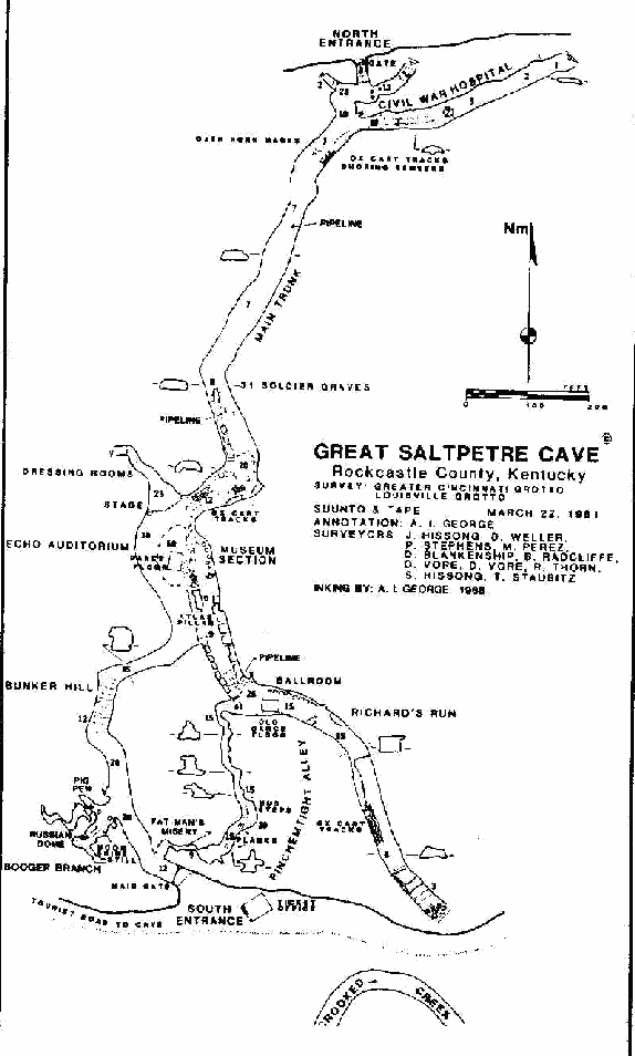
Nine cave maps are known to be associated with this cave. The first cave survey was made in 1805 by John James DuFour (George, 1987a, p. 10). This consists of a high quality compass and chain survey of the cave. The map is the first instrument survey of a cave produced in America. DuFour (n.d.) also drew a pencil sketch cave map during the same time period. The pencil map is probably older (by a few months) than the compass and chain map. The DuFour maps were made to exploit the saltpeter resources in the cave. Thomas Jefferson's 1782 sketch map of Madison's Cave, Virginia, is the first cave map in America (Jefferson, 1790; Halliday, 1968, p. 22). A sketch map copy of the DuFour instrument survey was made by Eleuthere Irenee du Pont from a Samuel Brown manuscript text dated November 10, 1805. An instrument vertical survey probably was conducted by DuFour. Such was needed to design an operational hydraulic pipeline and pumping system. This survey has not been located.
In 1960, William H. Russell and Thomas R. Costello (1963) visited the cave and produced a high quality Brunton and tape survey. An edited and redrafted copy of this map was published in the 1963 Speleo Digest. In 1966, Wayne R. White, William Adams, Charles Hall and Don Stewart produced a specialized Brunton and tape survey that shows the distribution of leaching vat areas and mining activity. James R. Rebmann and Gary A. O'Dell (1972) copied and added some annotation to the Russell and Costello map. Bobby Wainscott made a sketch map in 1973. The map is a free hand copy of the Russell and Costello survey. In 1981, Greater Cincinnati and Louisville grottos produced a high quality Suunto and tape survey of the interior Geography of the cave. Using the Greater Cincinnati and Louisville grottos survey as a base map, an on-site reconnaissance was made on October 19, 1986. Purpose of the trip was to annotate the map for the correct display of engineered constructions between the Soldiers Graves and South Entrance (Figure 1).
Two specialized cave maps using the Greater Cincinnati and Louisville Grottos survey base map show the distribution of hoppers in 1805 (Figure 2), and one possible engineering reconstruction of mining activity at the end of the War of 1812 (Figure 3).
A preliminary inventory of place names, saltpeter hopper distribution and changes in the physical geography is made in Great Saltpetre Cave. Mining saltpeter and contemporary tourist development has modified the geography of the cave. Interpretation of cave maps, physical descriptions and on-site inspection, provides a partial reconstruction in the pattern of saltpeter hopper placement from 1802 to presumed saltpeter mining and hopper building during the Civil War (Figure 2 and 3). No primary documentation has been found for the mining of saltpeter during the Mexican War (1844-1848) nor the Civil War (1860- 1864). Oral traditions of the Richard Mullins and David D. Singleton families are the only indirect evidence for this period of activity (George, 1985, 1987b). These oral traditions are suspect until solid primary documentation can be discovered.
CAVE NAME
The first name of the cave was Saltpetre Cave (Hunter, 1802). By 1804, it was called Kincaid's Cave and in the following year, it became known as Salt Peter Cave on the Rockcastle (Brown, 1804; Madison County Order Book, 1804). As the fame of the cave grew, a saltpeter marketing strategy may have been elected to change the name to Great Salt Petre Cave. This name was first inscribed on a map of the cave by John James DuFour (1805). He also names the North Entrance and the South Entrance (Figure 2). Samuel Brown (1809, p. 236) published a saltpeter article in the Transactions of the American Philosophical Society; in which the Transactions changed the name of the cave to "great cave on Crooked Creek." The printer used lower case letters for the cave name. Eleuthere Irenee du Pont's hand written manuscript copy of Brown's (1805) saltpeter monograph shows the cave name in upper case letters. By 1815, the cave was called Big Cave (Lewis, 1815; Rafinesque, 1832, p. 27; Collins, 1847, p. 501). After which, the name was changed back to Great Saltpeter Cave (Collins and Collins, 1874, p. 691). John Lair, Dr. and Mrs. Walker Owens purchased the cave in early 1940 (White, in manuscript, a); and using the archaic spelling, they renamed the cave, Great Saltpetre Cave.
SOUTH ENTRANCE
On the left, inside the South Entrance, are a number of saltpeter related artifacts. One rail of a demountable log ladder with angled mortises. The ladder originally belonged in Crooked Creek Ice Cave. Two water troughs and an assortment of sawed, dressed, square cut timbers, mostly corner posts, with mortise W angles and trunnel holes. Timbers appear to be pre- 1815 parts of rectangular and V-vat saltpeter hoppers. This is based on the high degree of wood workmanship, and imprints of wood molds present in rectangular vats located in Richard's Run. Other large timbers of similar design are scattered through out the cave, especially the Shoring Timbers in the north end of the cave.
Richard Mullins (personal communication, March 2, 1985) recounted about a large hole in the middle of the floor, not far from the South Entrance. This saltpeter test pit was filled in during the initial commercialization phase of development.
Figure 1
Not far from the drip line of the South Entrance is the most popular location for the moonshine operation. It was found on the west side of this passage (White, in manuscript, b, p. II). Pigs were also kept and fattened up in the Main Passage. Contemporary retelling of this story has the moonshine still in the Booger Branch and the hogs were kept in the Pig Pen passage.
BOOGER BRANCH
Booger Branch (Figure 1) is the first side passage on the left. This name was first used when the cave was opened to the public on July 27, 1941 (White, in manuscript, b, p. 12). Named because this part of the cave is supposed to be haunted by the ghost of a dead slave buried here. A Booger is a name for a ghost or specter in eastern Kentucky folklore. The "grave" is actually a rectangular saltpeter vat. The passage contains the remains of a reconstructed moonshine still; the Pig Pen passage; and the Russian Dome (Warm Room). The Warm Room or Russian Dome (Figure 2) are two of the oldest place names in the cave (DuFour, 1805; Brown, 1805 and 1809). In 1805, the Pig Pen was called "Scots Hole" (sic.). It was named for Alexander Scott, a Lexington, Kentucky, merchant who owned part of the cave in 1804. White (1967) misspells Booger as Bougher Branch on his map and article on the cave.
Rebmann and O'Dell (1972, p. 56) show two opposing hoppers about 40 feet inside the Booger Branch. Their location is better shown on a map made by Greater Cincinnati and Louisville grottos in 1981. Only one hopper is grossly recognizable as a large mound of sand and gravel. A pot hunter trench in the middle of the feature has destroyed some of the integrity of the vat. All of the vats supporting wood structures have been removed.
To the right of Booger Branch entrance passage (Figure 1 and 2) is the mapped location of a side passage (DuFour, 1805). The passage is now buried below the level of the tourist trail. Inward solution sculpturing on the limestone wall shows the position of this passage. The miners or commercial developers may have covered up the entrance to this passage. Nearby on an over hanging ledge is a lamp seat. Below the lamp seat is the approximate location of 3 rectangular hoppers built in 1805 (Figure 2). Three additional hoppers were found to the left of Booger Branch entrance. All vestiges of the 6 hoppers in the entrance passage along the west wall have been removed. DuFour (1805) called this area the New Hopper Room.
BUNKER HILL
Proceeding on into the cave, is a steep slope known today as Bunker Hill (Figure 1) . Although, Wainscott (1973) called it North-Northwest. And DuFour (1805) originally named it the Top of the Hill (Figure 2).
Along the west wall are lamp seats and numerous examples of pick ax marks to a height of 6 and 7 feet above the trail. Engraved and smoked tally marks are also present. Fifteen feet above the floor (on the west side) are high ledges showing examples of soil excavations. The major composition is sand and sandstone gravel detrital lag deposits. George Hunter made this general observation about this kind of sediments in 1802. Many of the presumed Civil War era hoppers in the Museum Section contain this formation.
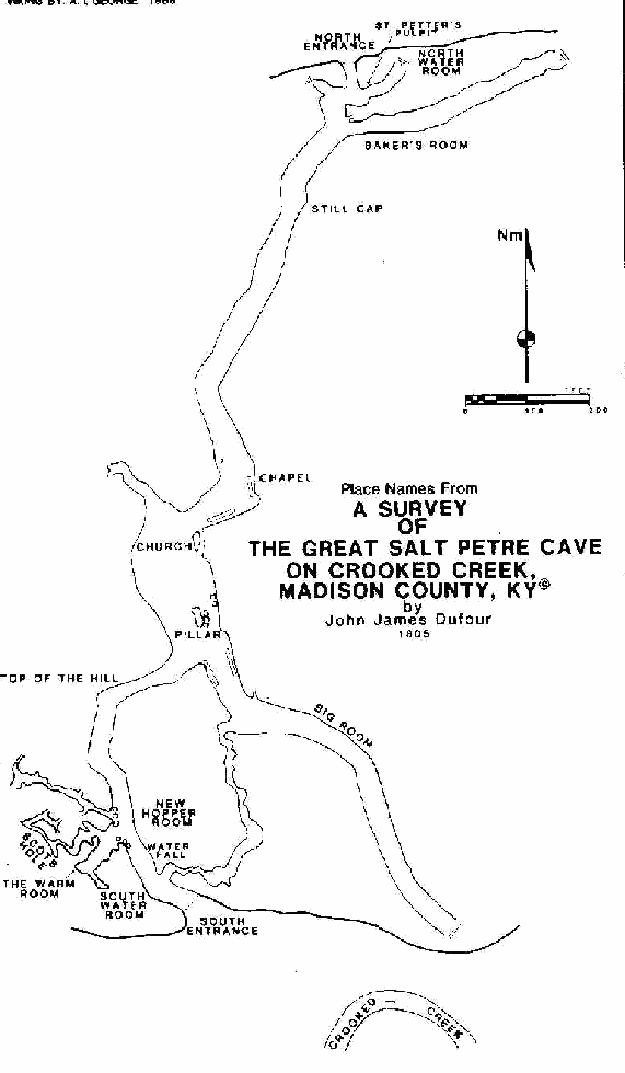
Figure 2
ECHO AUDITORIUM
The Maypole or Ball Room (White, 1967, p. 173) was changed to Echo Auditorium after re-commercialization in the early 1970s (Figure 1). In 1805, DuFour called this room the Church (Figure 2). Bulldozer improvements in 1967 and early 1970(?) has removed all vestiges of saltpeter activity. Based upon a number of cave maps and an eye witness account by George Hunter in 1802, we can reconstruct some of this activity. Hunter (1802, P. 47) makes reference in his narrative that, "here & there [rocks] are fallen down from the arched ceiling immense Stones which have been in part moved to make the road." This road was probably on the west side of Echo Auditorium. Russell and Costello (1962) mapped the cave in 1960, and show two large west facing excavations down the west center of the room. Much large breakdown filled the center of the room to a height of 16 feet (White, 1967). The breakdown pile contained a tumble down area. On-site observation of other tumble down areas in the cave indicates references to V-vat sites. Once the wood supports have been removed, the vat tips over. Echo Auditorium hosted a 180 feet long stretch with gangs of V-vats, probably positioned along the west toe of the breakdown pile. White's map shows a stipple area covering most of the floor of Echo Auditorium. And that suggest the V-vats were placed over the breakdown mound.
Positioned in this room and north of the Atlas Pillar was a large rectangular shaped crib like construction of flat stone (Paul Hohweiler, personal oral communication, 16 July and 28 August 1988). The floor was faced with broad flat stones, sloping inward in such a way as to channel(?) leachate toward one end of the structure. Hohweiler said that he and Burton Faust inspected this unique feature. Faust, according to Hohweiler is reported to have remarked that this stone crib could have been the first vat built in the cave.
Mammoth Cave has similar stone walled structures with wooden hoppers constructed on top of a high foundation of stone. The cavity below the Mammoth Cave hoppers is called an air chamber. The Great Saltpetre Cave crib feature was approximately 4 feet b y 8 feet. This is small when compared to vintage DuFour Style I hoppers. And probably one half of an air chamber. If two of these were originally together, then they would approximate the size of a DuFour hopper. Great Saltpetre Cave is probably the first cave to use the concept of the air chamber. And that idea was transplanted to Booth's Amphitheatre in Mammoth Cave.
Hohweiler said a lower level passage existed below Echo Auditorium. A slit opening was found just north of Atlas Pillar and south of the rock crib feature. The passage entrance was filled in with rock and dirt during the bulldozer leveling of this room. This activity destroyed the rock crib, V-vats and all other artifactual material in this room. All of this material was taken out of the cave for the construction of the parking lot.
SALTPETER MUSEUM
Reference to Atlas Pillar was made by Singleton (1968) and first appears on the Greater Cincinnati and Louisville grottos 1981 map of the cave (Figure 1). In 1805 it was called the Pillar (Figure 2). East of the feature is the Saltpeter Museum. Bulldozer improvements in the area of the Saltpeter Museum, has removed much vintage saltpeter artifact material. White (1967, p. 173) shows hopper areas along the east cave wall and east and north wall of the Atlas Pillar (museum side). Russell and Costello (1962), show 5 rectangular vats in this part of the cave. No authentic vats are presently visible in this part of the cave.
A life size reproduction of a rectangular saltpeter hopper is on display next to the east wall of the Atlas Pillar. It is built, crisscross fashion with stacked open logs, whose inside is walled with vertical shake shingles. The base of the vat is fitted with a half round, hollowed out, imbricate (log- in-log) filter. Some of the large exterior wall support timbers and the hollow log collection trough appear to be authentic material. Charring of the ends of the wall logs and observation of charred interior log molds in authentic vats, suggest some vintage logs formed the external super structure of this restored vat. The rest to include the imbricate log filter are made of new material. Restored model hopper design was based upon vat constructions in Great Saltpetre Cave (Richard Mullins, personal oral communication, March 2,1985). Wayne R. White (personal communication, October 30, 1988) found physical evidence for this imbricate filter in the cave, north of the Chapel and on the west side of the main cave. The imbricate log filter system can be seen in the Rotunda of Mammoth Cave, Edmonson County, Kentucky; Cumberland Caverns, Warren County, and in Big Bone Cave, Van Buren County, Tennessee (Figure 4). There are major constructional differences between the Tennessee and Kentucky sites. Anon. (1965a, p. 8) says that restoration of the Great Saltpetre Cave vats was going on at the time the Central Kentucky Grotto visited the cave (probably late 1964). A few years prior to 1965, John Lair had drawn up plans for the restoration of the vats (Anon. 1965b).
Saltpeter artifacts on display in the Museum are the results of John Lair's penchant for collecting pioneer hardware. Everything with the possible exception of some of the hollow log troughs are not native to this cave. The 3 cast iron kettles are not authentic saltpeter kettles. The kettles lack the wide nesting rim so typical of this specialized piece of equipment. A small portable V-vat on display was originally found and moved from Crooked Creek Ice Cave by the commercial developers after 1966 (Hohweiler, 1978, p. 66). The saltpeter ox cart lacks authenticity because the wheels are much too large. The small powder mortar is the kind used in a cottage industry and probably not used in this cave as part of the overall industrial complex. The one millstone was manufactured by John Lair because the original one allegedly found in the cave was stolen (Paul Hohweiler, personal oral communication 16 July 1988).
Immediately north of the Atlas Pillar is a large assortment of dressed corner posts, planking and wood strips from a number of vats (Figure 1). Contemporary half round, hollowed out logs used for the imbricate filter system is inter-mixed with authentic lumber. No authentic half round logs were seen in the cave nor as molds in the Saltpeter Museum, Chapel or Richard's Run.
Located just south of the intersection of the entrance cave passage with the Atlas Pillar were two gangs of V-vats in 1805 (Figure 2). These vats were built adjacent to the east and west wall. Each of the gang of vats was about 40 feet long. There were 3 rectangular vats positioned along the east wall of the Atlas Pillar. And 2 rectangular vats east of the Atlas Pillar in the present day vicinity of the ox cart.
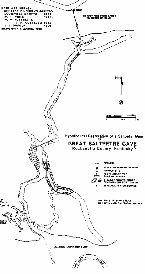
Figure 3
Russell and Costello (1962) mapped 5 rectangular hoppers south of the Saltpeter Museum. On-site inspection shows 9 rectangular hoppers built along the east wall; and 7 hoppers are constructed along the west passage wall (Figure 1). A sectional log trough once serviced the 9 vats. Only 5 trough sections are still in place. Workmanship and design of some of the hollow log troughs are similar to those seen in Mammoth Cave and Teamers Cave. They therefore date to pre-1815. Other water troughs are crudely made and suggest a lack of wood workmanship. There are at least 3 access entrance ways to the wood leachate troughs. The vats along the west wall have their discharge end facing inward and used a common leachate collection trough. Style III vats are constructed with saddle notched logs; where as Style IV vats are constructed with crisscross stacked open logs (Figure 4). White (1967, p. 170) noticed this construction change and though the new vat design was introduced in 1844, at the on set of the Mexican-American War (1844- 1848). The management under John Lair assigned a Civil War date to these hoppers. The vats if of Mexican-American War or Civil War (1860-1864) era construction, may have operated in tandem with the vat complex southward in Richard's Run. Along this same side of the cave, evidence seen at the first hopper shows the remains of an older rectangular vat. This consists of one buried dressed up right corner post with W mortise angles. This is similar to three examples elsewhere in the cave and in molds of corner post in Richard's Run. Date of origin is post April 1805 to pre-1815. Apparently, Style I hoppers failed to function with later re-use south of the museum leaching station. The vats were either buried with lixiviated earth or torn down for the construction of Style III and IV models.
Hopper design change may have been the result of New Madrid earthquakes. Three devastating earthquakes occurred on December 16, 1811, January 23, and February 7,1812, coupled with hundreds of after shocks for more than a year. In Mammoth Cave there was major damage to the saltpeter hoppers and pump tower to the extent that it took management one year to repair the damage (George and O'Dell, in press). The earthquakes caused an interruption in the production of saltpeter through out Kentucky (McCall, 1812). Primary documentation is wanting for Great Saltpetre Cave, yet some tantalizing possibilities exist for explaining observed design changes in hopper construction.
The saltpeter leaching stations in Great Saltpetre Cave and Mammoth Cave share a common geographic feature. Hoppers in both caves reside on top of a high apron of lixiviated saltpeter earth. This is best seen in the Museum Section of Great Saltpetre Cave and in the Rotunda and Booth's Amphitheatre of Mammoth Cave. The Great Saltpetre Cave saltpeter apron is about 15 feet high and it overlies an undetermined thickness of unconsolidated cave fill. The wet soils from the leaching operation made the site a prime candidate for liquefaction during an earthquake (George, in press). The hoppers and any other construction would essentially sink into the sediment and result in structural damage to the engineered features.
Adjacent to the east wall and North of the museum exhibit is another pillar, now long since buried beneath the saltpeter apron (Figure 2). The saltpeter apron is 5-8 feet above the north approach passage and about 15 feet above the entrance floor to Pinchemtight Alley. Definitely some of the existing hoppers are built on top of older vat designs. Existence of the saltpeter apron suggests the saltpeter miners did not attempt much recycling of lixiviated cave earth. A tourist sign in the cave for the 1804 Works is in effect partially correct, correct to the point that the 1804 workings are found below the vats seen today.
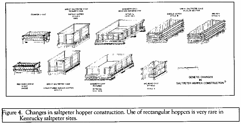
Figure 4
PINCHEMTIGHT ALLEY
This passage has under gone a lot of nomenclature changes. Lair (1973) reporting from a February 24, 1888 edition of the Mt. Vernon Signal called this passage the Devil's Race. David D. Singleton (1968) called it the Devils Colonnade. The Devil's Raceway is a variation on this name used by Russell and Costello (1962) and White (1967). Wainscott's (1973) map modifies this to Devil's Racetrack. Re-commercialization fostered a name change to Pinchemtight Alley (Figure 1). The 1981, Greater Cincinnati and Louisville Grotto survey restricts this name to a narrow passage constriction near the South Entrance to the cave. This same location is called Fat Man's Misery (Singleton, 1968). Figure 1, shows the extent of Pinchemtight Alley as the total passage length between Richard's Run and the south entrance passage. Fat Man's Misery (obviously borrowed from Mammoth Cave nomenclature) is relegated to a narrow part of the canyon passage.
The origin of Pinchemtight Alley may be related to Pinchemtight Hollow, Kentucky. John Lair during his early radio broadcast days in Cincinnati discovered and put together in 1931, the Coon Creek Girls. This was the first all girl fiddle band in America (Lair, 1957, p. 38). Pinchemtight Hollow is near Slade in Powell County. I suspect Lair named this feature in the cave to commemorate the Coon Creek Girls and their homestead.
RICHARD'S RUN
Going south out of the Saltpeter Museum and vat room, the steep slope of the saltpeter apron is encountered. Below the crest and to the left (east wall side) but beyond the last hopper is the remains of a hollow log pipe line. The exposed log is 10 3/4 inches in diameter and is augured out to an inside diameter of 3 1/2 inches (Figure 1). Pipeline slope is clearly south into Richard's Run. The somewhat flat "end" of the pipe suggest it to be the female socket joint. If so, then this pipeline section is the leachate discharge line (beer pipe) draining out of the cave from a presumed elevated pumping station in Richard's Run (Figures 1 and 3).
At the base of the saltpeter apron and to the right is the entrance to Pinchemtight Alley. Flanking the path to Pinchemtight Alley are the remains of V-vats. Most of the wood has been removed. Some of the vats look like they have been turned up side down. At least 5 vats are found here. To the left of the Pinchemtight Alley is an area that White (1 967) called a tumble down area. There are two large earthen lumps in this area that could be the remains of V-vats. Bulldozer improvement has removed much artifactual material from this area.
The Big Room (DuFour, 1805), The Ballroom (Russell and Costello, 1962), Southeast Passage (Wainscott, 1973) or Richard's Run (White, 1967), has undergone a number of place name changes (Figure 1). Greater Cincinnati and Louisville grottos (1981) map does not name this passage, yet restricts the Ballroom to the small vicinity of the Old Dance Floor platform. Richard's Run passage contains some of the oldest saltpeter hoppers in the cave. From design criteria only, these vats probably date from post April 1805 to pre- 1815. Second generation Style Ia vats can be seen in Booth's Amphitheatre at Mammoth Cave (Figure 4). Russell and Costello (1962), indicate 5 rectangular vats; whereas, Rebmann and O'Dell (1972) show 8 rectangular hoppers. There are actually 9 rectangular vats positioned along the east wall of the cave. A hollow wood trough collected leachate from the vats. Only one trough is represented in this section of the cave. On the west side of the cave are examples of areas excavated for saltpeter dirt. Pick ax marks indicate removal of fill from 6 to 7 feet high. White (1967, p. 173) shows this side of the cave was a site for rectangular vat placement; today, no evidence is apparent. Based upon photographs and map (White, 1967, p. 172) and Paul Hohweiler (personal oral communication, 16 July 1988), establishes the existence of rectangular vats along the west wall. All direct evidence is now gone. Leveling operation for the construction of the dance floor has removed these artifacts. There is enough room for 7 or more rectangular hoppers. A wood sign says the Richard's Run vats represent Civil War construction. This is not true; these vats represent pre- 1815 saltpeter vat design and construction.
Bulldozer leveling for the old Ballroom dance floor has lowered the floor of the cave from 1 to 2 feet. This activity destroyed much of the buried front ends and specialized floors of the rectangular hoppers along the east wall.
Based upon lamp seat marks along the east wall, suggest the present floor of the cave to include the position of the rectangular hoppers, has been lowered at least 7 feet, during 2 stages of saltpeter excavation.
Beyond the vat area to the south, the miners have leveled the floor and excavated a wide trench. Beyond the trench are a number of ox cart tracks that lead from another deep bisecting excavation trench. The saltpeter miners used mattocks to excavate these soils. Near the end of this passage in the vicinity of the breakdown is another rectangular hopper processing center (Paul Hohweiler, personal oral communication, 16 July 1988). Visitor traffic and vandalism has removed vestiges of this operation.
CHAPEL
Going north out of the Echo Auditorium, one descends about 6 feet lower down a slope to a level floor. Russell and Costello (1962) and White (1967, p. 173) shows a string of vats flanking the east and west walls. The Russell and Costello map shows 2 excavations along the west wall and 6 rectangular hoppers in this section of cave. White shows ox cart tracks ascending a shallow grade into Echo Auditorium to the left (west) of the trail (these still exist). The vat complex along the east wall has been removed. This area through the passage bend was called the Chapel (Figure 2), and hosted near the east wall, two gangs of 20 and 40 feet long V-vats (DuFour, 1805). White (1967) shows this area as a tumble down. The south V-vat gang is still in place, although further out in the middle of the passage (Figure 1). The north gang is very subdued. Lateral pit excavations are found adjacent to the wall.
Across the passage and along the west wall is a gang of 7 rectangular hoppers. Six of the vats are constructed in units of two inward facing tanks and approachable from a ramp leading from the main trail. This was probably made to facilitate placement of one leachate collection trough. From measurements and observations, it is apparent that the Chapel rectangular hopper complex is similar to that seen south of the Saltpeter Museum. Therefore, the vats date within the same time period. The vats were constructed "quick and dirty" and lack the refined wood workmanship so apparent with those seen in Richard's Run.
Wayne White (personnel communication) found evidence for the imbricate filter system in this part of the cave. The rectangular hopper with this feature was located on the west side of the passage and the furthest north in this gang of vats.
NORTH END OF THE CAVE
The north end of the cave was called the Main Trunk (White, 1967). Since that time, the passage has not been referred to with any designating name. There are individual place name sites positioned along that passage (Figure 1).
Just beyond the Chapel vat complex and along the west side of the passage are piles of culled and irregularly stacked rocks. There is also a large high wall excavation. Along the right (east) side of the passage are piles of earth. About 30 feet south of the Soldiers Graves is the exposed remains of one hollow log pipe line.
As for the presumed 31 graves of 8 Union soldiers and 23 slaves residing in the cave. There are no facts to support such a tradition for the graves nor the Civil War Hospital located at the next passage on the right. There is one open "grave" with loose dirt spread outward from the excavation. This is a recent excavation based on the non-compacted nature of the excavated fill. If of Civil War vintage, then the dirt from the excavation should have been as tightly compacted as is present in the other hummocks. There is no direct historic nor archeological evidence for graves. There is every indication that these hummocks are lixiviated saltpeter earth dumps placed between 30 V-vats; and these occur on White's (1967) map as ridge dumps. Recent folklore tradition of soldiers' graves is definitely more exciting than mundane saltpeter mining practices. To date, no historic information has been found to document the Civil War hospital, graves of soldiers and slaves nor saltpeter mining during the Civil War. Stories of the graves date to 1967 when the cave was first wired for electricity. Since that time the story has become more embellished and is a direct clone of the mythical slave grave in Booger Branch.
DuFour in 1805 called the area in the vicinity of the northern most ox cart tracks, the Still Cap (Figure2). A still cap is a distiller's term used for a device that fits on top of a brandy still (DuFour, 1826, p. 260).
About 100 feet south of the Shoring Timbers is another exposed hollow log pipe. The shoring timbers are dressed lumber with mortises and trunnel holes and once were part of the vat length support rails. The Shoring Timbers were erected in the cave to protect examples of ox cart tracks. The timbers are now about 6.5 feet long. Two feet long sections of these sawed timbers remains on the floor across the tourist trail from the shoring timbers. Other than the locked iron bar gates on each cave entrance; the shoring timbers is the only barrier erected to preserve an artifact in the cave.
The Civil War Hospital (Figure 1) was first called Baker's Room (DuFour, 1805). Named for John Baker, the official discoverer of the cave in 1798 (Brown, 1805 and 1809, p. 236). The next passage on the right, DuFour (1805) named the North Water Room and "St. Petters Pulpit" (sic.) is found on a ledge at the junction between the North Entrance passage and North Water Room (Figures 2).
NUMBER OF SALTPETER HOPPERS
Five distinct saltpeter hoppers have been constructed in the cave (George, in manuscript; Figure 4). The saltpeter hoppers are represented by V-vats, DuFour crib vats (Style I and Style II) and pig pen (Style III and Style IV). Age relationship is at present difficult to ascertain. The V-vats were probably operational from perhaps before 1800 to 1815. The DuFour hoppers (date) from early 1805 to perhaps 1815. The pig pen hoppers may have been built after the December 16, 1811, New Madrid earthquake. No primary documentation have been discovered for saltpeter mining during the Mexican American War or Civil War. The earliest reference to these war dates is based on traditions published in 1939 by Ralph Griffin.
The reason for so many different mapped numbers of hoppers in the cave is directly related to using stylistic cartographic symbols to display the cultural geography in the cave (Table 1). We get a generalized picture both in placement and numbers of hoppers. Furthermore, a few of the vats are hard to identify as saltpeter hoppers. All of the maps were artistically executed in this style with the exception of the 1805 DuFour map (Figure 2) and the annotated copy (Figure 1).
Hunter (1802, P. 47) says "we found about 20 hoppers in the cave in two or three places, [illegible] the earth, as we learnt that they found water in some parts of the cave in the winter when they worked them upon the spot without the trouble of moving the earth -". Hunter describes V-vats and not rectangular hoppers in the cave. In 1805, there were three places in the cave containing a water source. The North Water Room, the South Water Room at the end of Booger Branch, and a waterfall, found along the east wall, just north of Pinchemtight Alley in the south entrance passage (Figures 2 and 3). Observations in the cave show an additional source in Pinchemtight Alley. This passage in 1805 may not have been fully excavated to reveal this fourth water source. The 1802 vats would have to be close to these water sources. The first V-vat complex seen by Samuel Brown and George Hunter in their 1802 reconnaissance would be just south of the Civil War Hospital (Baker's Room). Casts of the hoppers are still in that part of the cave. Probably 7 V-vats made up each processing center. This led White (1967, p. 171) to believe saltpeter mining activity started in the north part of the cave before expanding southward. The area around the Chapel may have been operational in 1802. Provided that water would have to be transported there by oxen. The pipe line had not been built during the 1802 visit by Brown and Hunter; because it was Hunter who proposed a plan to better work the cave by transporting water from the cave's springs to the hopper areas through a pipeline. With John James DuFour's retention at the cave; he expanded the processing center to the Museum Section and the Booger Branch area in what he called The New Hopper Room (Figure 2). Post 1805 rectangular hopper construction was installed in Richard's Run and probably represents at least 2 generations of vat building, disassembling, floor excavation and vat rebuilding. The sequential event lowered the floor at least 7 feet.
The DuFour cave survey of 1805 shows 11 rectangular hoppers and 4 gangs of V-vats (Figure 2). Based upon length measurements, about 45 V-vats would have been operational at this time period. Hunter (1802, p. 47) makes reference to 18 saltpeter and 8 ash hoppers near Crooked Creek located beyond one of the entrances, probably the South Entrance used by George Montgomery and William Smith's operation. Hunter said the other side of the hill had the largest processing center, and was operated by James Kincaid. He talks about furnaces but no information on the number of vats in operation.
Sometime after April 1805 at the east entrance to Pinchemtight Alley in Richard's Run, the miners constructed two gangs of perhaps 7 V-vats (Figures 1 and 3). George Hunter (1802, p. 47) established processing of dirt for saltpeter recovery could only be done in the cave during the winter months. Water sources in the cave dried up during the summer and processing had to be done outside the cave next to Crooked Creek. Probably by April 1805, Brown, Hart and Company had solved this seasonal problem by installing a pumping lift station beyond the North Entrance (DuFour, n.d.). A notation on the map says water was pumped up from Crooked Creek. The sump in-take tank at creek level below the base of the pumping tower was misinterpreted as the foundation to a gunpowder mill by Singleton (1968, p. 8). Water was pumped up 80 feet from Crooked Creek and gravity drained through a hollow log pipe line to the saltpeter vat processing centers in the cave. Placement of vats in the Chapel and Saltpeter Museum supports the idea of an operational pipe line system at the time DuFour completed his map in April 1805 (Figure 2 and 3). Placement of the pump tower(s) beyond the North Entrance clearly is required before a pipeline could supply Crooked Creek process water. I think two or possibly three lift stations would be required to pump water up the steep hill to the North Entrance. Construction wise, two towers, 40 feet high is a lot easier to build than one 80 feet high structure. Presence of a female pipeline socket end (at the north entrance to Richard's Run) is proof for a leachate return pipeline to furnaces outside the North Entrance. Great Saltpetre Cave is the architectural prototype model used by Charles Wilkins and Fleming Gatewood at Mammoth Cave. Mammoth Cave has two pipelines buried in the floor of Houchins Narrows and an elevated double pipeline at the Methodist Church.
Taking all remaining artifacts, historical review of published and unpublished literature, I am able to assemble one possible hypothetical representation of what the saltpeter mine may have looked like toward the end of its active manufacturing life (Figure 3). The most conjectural aspects are the placement of the two pumping stations in the cave; and the placement of the pipeline, especially points at which the pipeline bifurcates. Two pipelines were needed in the cave; one to bring water into the cave and the other to take vat leachate out of the cave to furnace evaporation centers. Placement of the two pumping stations beyond the North Entrance, requires each pump station to be over 40 feet high. The presumed double tandem pump station at the en trance to Mammoth Cave was at least 45 feet high (Mullin, 1986, p. 17).
The number of remaining rectangular saltpeter hoppers in the cave is truly astonishing. There are existing at present, 34 rectangular vats in the cave. Taking hopper site placement from DuFour (1805), Russell and Costello (1962), White (1967) and this investigation, an extrapolation of a minimum of 65 rectangular hoppers is thought possible. Only about 43 of these hoppers could be fully operational at any one time.
It should be pointed out that pre-1815 Mammoth Cave operation had only 10 rectangular hoppers, 3 rectangular water tanks with pumping stations, and at least 28V-vats (Ridgely, 1811 ab; Mullin, 1985, p. 3-4). Based on census of vats in Great Saltpetre Cave and DuFour's 1805 map, I can project that up to a change in management or later time event (signaled by the introduction of Style III and IV hopper designs), Great Saltpetre Cave production center contained about 29 rectangular hoppers and at least 4 gangs of V-vats. The Operation at Great Saltpetre Cave, using slightly smaller hoppers, was a larger saltpeter factory and must have out performed Mammoth Cave by about 30 per cent.
CONCLUSION
Great Saltpetre Cave is remarkable for the number of saltpeter hoppers still in the cave. Commercial development for a tourist attraction began in the 1940's and intermittently shown to the public to the Fall of 1985. The cave has been subjected to intentional vandalism, local wood foraging, and moonshine operation have wrecked havoc on the saltpeter artifacts. Even so, the cave is a treasure trove of early industrial chemical Americana. Five completely different styles of saltpeter hoppers are known from this cave. Circa 1802,1805 and post 1805 V-vats are found in three different places in the cave. Unique style of rectangular hoppers were built in 1805 for Brown, Hart and Company by John James DuFour (George, in manuscript). Style I survives to the present. Style I hoppers and the imbricate filter system on Style II hoppers, air chamber and hydraulic system were copied and imported to Mammoth Cave. Style III hoppers consists of saddle notched crisscrossed logs. Style IV vat is the crisscross or pig pen method of hopper construction. Style III and IV may represent a change in management, post 1811-1812 New Madrid earthquake construction, or both at the cave prior to 1815. Dendrochronological analysis of logs used to construct these saltpeter hoppers could resolve the time period of new hopper construction. This is definitely a subject for additional research.
ACKNOWLEDGEMENT
Thanks is extended to the American Philosophical Society, and the Hagley Museum and Library for permission to use and quote from unpublished maps and manuscripts connected with the Brown, Hart and Company saltpeter industry. Particular appreciation is extended to the following reference librarians who secured much needed documentation: Ms. Beth Carroll- Horrocks, American Philosophical Society; Ms. Marjorie G. McNinch, Hagley Museum and Library; Ms. Pat Hodges, Kentucky Library, Western Kentucky University; Mr. James J. Holmberg and the staff at The Filson Club; and the Kentucky Room, Louisville Free Public Library, helped with finding much needed documentation. Mr. and Mrs. Stanley and Jeanette Rein, past owners of Great Saltpetre Cave, gladly gave permission and accompanied the author during his investigation of the saltpeter artifacts. National Park Service at Mammoth Cave gave permission to study saltpeter activity in Mammoth Cave. Ms. Marsha A. Mullin, Project Historian, Historic American Engineering Record, National Park Service, provided insight into early americana chemical engineering technology at Mammoth Cave. Dr. Wayne R. White and Mr. Paul Hohweiler shared much of their personal observations conducted in the cave prior to the 1967 commercial destruction of artifactual material. My wife, Diana Emerson George provided field assistance, acted as photo archivist, and gave much encouragement during the course of this work.
OCR work done by Andy Niekamp