Figure 1
GREAT SALTPETRE CAVE, ROCKCASTLE COUNTY, KENTUCKY
A Geology and Archeology Field Guide.
Authors:
Scott A. Engel
NSS 32520
and
Annette Summers Engel
NSS 31319
From the March 1998 Greater Cincinnati Grotto Electric Caver Newsletter
INTRODUCTION
This field guide is intended for the average caver to appreciate the geologic and archeological history of Great Saltpetre Cave. The text can be read in association with a trip through the cave, or as a follow-up to a previous walk-through. The main objective of this documentary is to gain an appreciation for the extensive amount of time represented in caves. By exploring Great Saltpetre Cave, we will grasp an understanding of the cave's complexity, unlocking clues of its formation and modification thousands of years ago.
REGIONAL GEOLOGY
Rockcastle County is divided by the Pottsville Escarpment which separates the Mississippian Plateau to the west from the Cumberland Plateau to the east (Figure 1). The eastern portion of the Mississippian Plateau, underlain by the St. Louis and Ste. Genevieve Limestones, is a broad plain with little relief and is characterized by localized karst development. The Cumberland Plateau is a highly-dissected upland, underlain by Pennsylvanian-age (320-280 million years ago) shale, sandstone, and coal units (Sable and Dever, 1990). Within the western portions of the Cumberland Plateau near the Pottsville Escarpment, the stream valleys are more deeply entrenched into the underlying bedrock, to expose Mississippian-age (360-320 million years ago) carbonates. Cave systems in this region are developed within the Newman Limestone Formation, which is composed of the Upper, the Ste. Genevieve, and the St. Louis Limestone Members (Figure 2). In general, the carbonate units occupy the mid-sections of ridges and are capped by Lower to Middle Pennsylvanian sandstones. The lower portions of the hillslopes and the present valley floors are within the less soluble shales and siltstones of the (Mississippian) Bordon Formation.
Figure 1
All passages in Great Saltpetre Cave (Figure 3) are developed within the Ste. Genevieve Limestone Member. Identifying features of the Ste. Genevieve Limestone that can be observed within Great Saltpetre Cave include: 1) From entrance to Echo Auditorium: limestone is light gray, with some oolites (rounded accretionary bodies, resembling fish eggs 0.25 to 2 mm in diameter), pellets, and coated fossils. Low-angle cross-beds in planar sets up to 0.5-1 m thick. Few dark gray chert zones; and 2) Main Trunk: low-angle cross-beds, with some truncations marked by gray shale at tops of cross-beds. Great Saltpetre Cave is located within the Crooked Creek drainage basin, occupying about eight percent of Rockcastle County (O'Dell, 1992). Generally, Crooked Creek drains southwest into Roundstone Creek. However, in the reach of the drainage basin that includes Great Saltpetre Cave, the creek makes several sharp bends so that water flows southeast for a short distance. These stream meanders create several isolated high ridges where Great Saltpetre Cave and several other caves reside (e.g. Hard Baker Cave, Crooked Creek Ice Cave, Mullins Springs Cave). These geomorphic features standout on a topographic map or can be observed directly by hiking the Crooked Creek on the Great Saltpetre Preserve trails. It is hypothesized that Crooked Creek takes this tight meandering route due to a localized structure, such as a fracture zone, an old fault trace within the bedrock, or a depositional bulge formed in the underlying Mississippian units. Such structural features serve as weak zones within the bedrock allowing for faster erosion and preferential cavern development.
The Crooked Creek drainage, north of Great Saltpetre Cave, is dissected by several very small faults, off-setting Newman Formation limestones from the Bordon Formation shales. The overall regional dip (located by structure contours on the Pennsylvanian Breathitt Formation; Brown and Osolnik, 1974) is to the southeast, at a gradient of approximately 0.02. However, near Great Saltpetre Cave, there is an irregularity in the southeasterly dip and units trend toward the northeast. It is probable that the localized change in dip is associated with the faults just to the north.
Figure 2
PASSAGE MORPHOLOGY AND CAVERN FORMATION
Relationships between cave passage morphology and interpretations about cavern formation, particularly with respect to time, can be determined by analyzing passage arrangement, size, and shape. However, in the interest of space, such a discussion will be limited. For more comprehensive reviews on cavern formation, one is directed to White (1988), Palmer (1981; 1991), Ford and Williams (1989), and Gillieson (1996).
There are several types of cave passages that can be seen in Great Saltpetre Cave, including tubular passages, canyons and canyons developed in the floor of tubes (keyhole), and vertical shafts (Figure 4). 1) Tubes are poorly preserved in Great Saltpetre Cave, but near the Pig Pen and in side passages near the North Entrance, a few can be observed.
These passages form while water completely filled the void (below the water table), as it flowed (sometimes slowly) through the passage. Therefore, these passages formed when the groundwater level and the Crooked Creek drainage were higher than the tubular passages.
Figure 3
This type of development is termed "phreatic". 2) Canyons, such as the one connecting the Ballroom to the South Entrance (Fat Man's Misery), are common in Rockcastle County.
These passages are formed above the groundwater table and by active water movement as it flows along limestone units (stream passages). "Vadose" is the common term for this type of passage formation. Most canyons are narrow and winding, while others can be quite large, such as the Main Trunk passage in Great Saltpetre Cave. Canyons can also form in the floors of tubes ("keyhole" passages), as seen in the Bunker Hill passage. The key-hole is a transition between phreatic and vadose passage development. For this to occur, the regional water table has to drop over time, establishing a new base level at a lower elevation than the original tubular passage. Water filling higher passages has to "catch-up" to the lowered water level, causing downward erosion and deepening in the floor of tubular passages, forming canyons. The alternative to the formation of key-hole passages would be an abandoned tube passage as the water gets redirected to a lower elevation passage. 3) Vertical shafts, or dome-pits, are formed by water flowing vertically through cracks and thin fissures in limestone. Over time, the fissures expand, walls of the shaft break-down, and the pit widens. Like canyons, shafts form above the active water table. In Great Saltpetre Cave, the Russian Dome is an excellent example of a dome-pit.
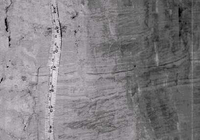
Along the walls of the passage leading back into the Russian Dome area are morphological structures suggesting that this region of the cave was a lift tube. A lift tube is formed by water from a lower passage being forced upward by hydrostatic pressure into a larger overlying passage (similar to an artesian system). The lift tube can be identified today by high angle fluting and scalping along the passage walls that angle toward the lower passage and cut across structural features in the bedrock (Photograph 1). A second lift tube has been tentatively identified in the main passage near Bunker Hill. Assuming that the theory for lift tube formation is correct then a lower passage infilled with sediment must exist in this portion of the cave. A lift tube has also been identified in Crooked Creek Ice Cave suggesting that this area had a very unique hydrologic system at one time.
Figure 4: Cross sections showing typical cave passage
Past researchers have estimated the formation of caves in Kentucky to have been prior to 10,000 years ago, or even before glacial advances more than a million years ago. While these times are speculative, work in Mammoth Cave (Palmer, 1981; Schmidt, 1982) and in Tennessee caves (Sasowsky et al., 1995), suggests multiple formation times and several mechanisms by which the caves have developed. More evidence, some of which will be discussed later in this guide, needs to be collected to verify the timing of passage development in Great Saltpetre Cave
SEDIMENT STUDIES IN GREAT SALTPETRE CAVE AND HARD BAKER CAVE
Almost every cave around the world contains sediment deposits consisting of clastic, chemical, or organic material that fill a portion or all of a cave. The deposit may be a simple coating of mud left in the corner of a small side passage or the massive volumes of sediment that once filled the passages of Great Saltpetre Cave.
Cave sediments can be a very useful, and frequently, the only tool for researchers attempting to determine the past history of a cave and the drainage basin to which it is hydrologically connected. Unfortunately, sediments can also be very difficult to study and interpret; therefore, many researchers tend to avoid sediment studies. Overall, caution should be executed when inspecting cave sediment stratigraphy because of unconformities (gaps in time between each deposit) and facies changes (lateral and vertical variations of a sediment package with itself over some distance). Much like surface stream deposits, the fluvial nature of cave sediment deposits creates a high degree of variability within the confining space of the cave passage. Limited stream movement due to these spatial constraints causes constant reworking of already deposited material causing an increase in the complexity of the deposits and frequently obscuring useful interpretations.
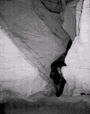
Photo 1
Depositional Characteristics and Paleo-flow Direction
The sediment deposits within Great Saltpetre Cave are not simple laminar deposits (created by very low flow velocities on smooth surfaces), but show a complex assemblage of flow and channelization structures suggesting a complex depositional history. Multiple bedding, variable grain size, cut-and-fill features, and other flow structures attest to numerous erosional and depositional cycles (Photograph 2). The presence of cut-and-fill structures indicates sediment deposition by a free-flowing stream channel within the vadose zone. Clast imbrication (the preferential orientation of elongated clasts in the direction of water flow; Figure 5) indicates that the stream depositing the sediments was flowing from northwest to southeast toward the present day entrance (Krekeler et al., 1997). Therefore, if a straight line were drawn from the entrance of Great Saltpetre Cave southeast across the present valley and into the opposite ridge, it would intersect Hard Baker Cave. Sediments observed in Hard Baker Cave sho the same southeast flow. This flow direction is perpendicular to the present flow of the Crooked Creek drainage suggesting that a fundamental change within the drainage basin occurred between cave passage formation and the incision of the surface stream (Figure 6). To develop a large complex cave system like Great Saltpetre and Hard Baker before any influence or incisement from the surface drainage, implies that a large amount of time must have elapsed between cave inception and the development of the modern drainage system.
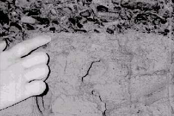
Photograph 2:
Abrupt contact between underlying laminated clays and overlying gravels in
Hard Baker Cave.
Figure 5:
Sediment deposit showing elongated clast imbricationcontrolled by stream
flow direction. Clasts plunge upstream (water flow was left to right in this
diagram).
Paragenesis, phreatic bedrock solution concentrated above sediment on passage floors and terminated at the water table (Renault, 1967; Ford and Ewers, 1978), could be used to describe the sedimentation mechanism within Great Saltpetre Cave. However, there are several reasons why the sediment accumulation and passage enlargement did not occur paragenically, also established by Palmer (1987) in Mammoth Cave: 1) cut-and-fill structures suggest channelized flow; 2) sediment nearly fills some of the passages to the ceiling, or did prior to sediment mining; 3) breakdown blocks are found within the sediment packages, supporting a large minimum passage height; 4) sediment fills tube passages that trend away from the main trunk canyon in Great Saltpetre Cave (and Hard Baker). The great width and depth of the Great Saltpetre Cave passages, coupled with the episodic nature of sediment fill, may indicate slow river entrenchment and aggradation on the surface. Climatic changes were probably the cause (Palmer, 1987), due to alternating rising and falling of stream levels controlled by surface runoff variations (created by precipitation fluctuations) or global sea-level changes (due to glaciations).
Figure 6: Cross section through Crooked Creek Drainage Basin.
Sediment Composition
Gravels
Gravel-size (8 cm - 4 mm) sediment is predominantly composed of sandstone, with lesser amounts of quartzite pebbles (Photograph 3). Two types of sandstones are present in the deposits - a tan colored sandstone and a deep brown sandstone. An important observation associated with a coarse-size fraction analysis is the conspicuous lack of carbonate clasts (Krekeler et al., 1997). To date, there are no supported explanations for the carbonate absence. The size of the gravels varies, but the maximum diameter observed is 8 cm. The water velocity required to transport this size of a cobble would have had to been at least 2 m/s.
Sands
The sand-size fraction contains dominantly quartz, with lesser amounts of heavy minerals identified as goethite, magnetite, ilmenite, hematite, spinels, and pyroxenes. The sand grains are generally very angular to sub-rounded in shape. Grain angularity suggests that the sediments have not been transported over a great distance. However, the presence of rounded grains does imply a complex, polygenic origin and transport regime for the material. The minerals found within the sand-size fraction could have derived from two sources. The majority of the minerals, particularly ilmenite, magnetite, spinels, and pyroxenes, likely originated from the breakdown of overlying Pennsylvanian cap rock. Smaller quantities of some of the other identified minerals, such as goethite and hematite, are documented soil minerals. Their presence suggests origination from overlying soils that were subsequently washed into the cave. These minerals form in humid temperate soils, implying that the sediments were possibly deposited in an environment similar to what presently exists.
Clays
Clay minerals make up 25-50% of the cave sediment deposits. Clay minerals include kaolinite, illite, smectite, vermiculite, lepidocrocite, goethite, and berthierine. In microscopic analyses, the clays have a detrital texture (meaning that they were washed into the cave), possibly from the overlying bedrock or from soil formation.
Relatively thick, continuous sequences of laminar silt and clay deposits exist on the surface of undisturbed sediment piles in the Ballroom (Photograph 4). When observed closely, these deposits contain cyclic fining-upward sequences only a few millimeters thick. These cycles represent pulses of fine-grained sediment that settled in a very low flow or ponded (lacustrine or slack-water) environment within the cave. One fining-upward sequence represents a period of slightly increased flow velocity that carried larger-size sediment, followed by a period of lower flow that deposited the finer material. This sequence of events was repeated hundreds of times in order to generate the deposits. Such cyclic depositional patterns could be the result of seasonal changes in the stream discharge, annual flooding, or storm events. Without reliable dating techniques, it is impossible to interpret the time needed to generate such deposits.
Photograph 4:
Laminated clay deposits in the Ballroom of Great Saltpetre
Cave
"Cottonball" Crystals in Great Saltpetre Cave
Tufts of fine, hair-like white crystals have been observed on occasion near the junction of the passages between the Echo Auditorium and the Ballroom. Closer inspection found clumps of crystals forming along cracks in the passage ceiling and subsequently falling to the floor. Ruling out other common cave minerals such as gypsum and aragonite, it was postulated that these crystals could be a nitrate mineral. Attempts to remove the crystals to a laboratory for analysis proved impossible because the crystals evaporated when exposed to surface conditions. Because saltpeter crystals, specifically niter, typically form in humidities lower than that of Great Saltpetre Cave (measured to be between 80-100% during different time of the year), and have not been reported to occur in caves in this part of the United States, the crystals are probably not nitrates.
A second possibility is that the crystals are a soluble sulfate, epsomite [MgSO4 ·2H2 O] or mirabilite [Na2 SO4 ·10H2 0]. These minerals are also extremely susceptible to variations in temperature and humidity. Epsomite is stable at a temperature range of 10 to 15°C and a relative humidity below 88% (Hill and Forti, 1997). At temperatures and humidities above this range, the mineral will deliquesce (dissolve). It is believed that air currents generated by the junction of the passages in Great Saltpetre Cave have led to ideal climatic conditions for the cottonball mineral growth. The seasonal appearance of the crystals (i.e. typically present in the winter months) suggests that climate within the cave is highly dependent on the outside surface conditions allowing for the ideal conditions for the growth of these minerals during limited times of the year.
DETERMINING THE AGE OF GREAT SALTPETRE CAVE SEDIMENT
Usually very little dateable and reliable material is located within cave sediment. If sufficient amounts of carbon or other organic debris, such as an old tree log, were deposited within the material, carbon-14 dating techniques might be used. This technique can only be used on material less than approximately 30,000 years old.
Bones or artifacts can also be used as dating tools to interpret cave sediment ages. A report published in 1884 (Anon., 1884:380-382) identified bones from Great Saltpetre Cave around 1805. The bones were found to be similar to some found in 1796 located a meter deep in sediments being mined for saltpeter in a cave in Greenbrier County, West Virginia (Shaw, 1992). The animal was described by Thomas Jefferson (1799) as a previously unknown species of the now extinct giant ground sloth, subsequently named Megalonyx jeffersonii (Cuvier, 1804). Bones of an extinct, flat-headed peccary (a pig-like animal), Platygonus compressus, have also been found in Great Saltpetre Cave (Wilson, 1985). P. compressus from Welsh Cave, Woodford County, Kentucky, have been dated by carbon-14 as 12,950 ± 550 years before present (Guilday et al., 1971; Wilson et al., 1975; Wilson, 1985). Current attempts are underway to find the original references of the bones in Great Saltpetre Cave and to verify these findings.
Although extremely interesting, material for carbon-14 dating and other paleontological evidence have not been located in the sediment. Because of this situation, less direct methods of dating have to be employed. Commonly, cave sediment may be covered by one or more carbonate crusts, such as flowstone, gypsum, or other speleothems. Speleothem dating makes it possible to calculate a minimum age for the sediment deposits, particularly if the formations overly sediment. However, these dating techniques, such as uranium series-dating and thermoluminescence, have their own limitations and are frequently cost prohibitive.
Another possible technique effective in cave sediment studies is paleomagnetism. The past paleomagnetic history is well established, in that during discrete intervals of the earth's past, the magnetic poles have switched polarity. Fine grained sediments (ideally silts and clays) that contain a percentage of iron and that were deposited in water have a tendency to orient themselves to the earth's magnetic field like tiny magnets. If the sediments were deposited during a time when the magnetic poles were reversed, then that reversal is preserved within their structural orientation and can be measured. Paleomagnetic sampling in Mammoth Cave has identified three separate paleomagnetic reversals preserved within the sediments that date as far back as 2.1 million years (Schmidt, 1982). Limited paleomagnetic sampling has been conducted in the sediment deposits within Great Saltpetre Cave and Hard Baker Cave (Photograph 5) and, pending the results, additional samples from Hard Baker and Great Saltpetre Cave may be collected.
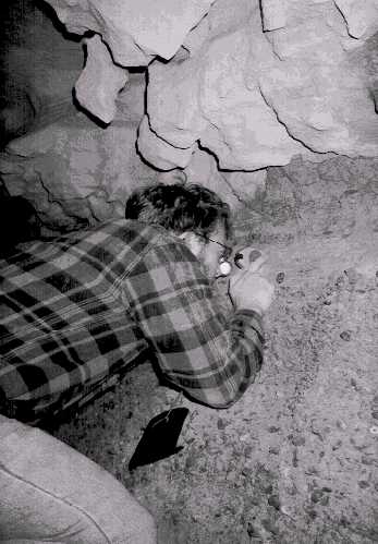
Photograph 5:
Collecting paleomagnetic samples in the Main Trunk of Great
Saltpetre Cave.
EARLY EXPLORATION AND SALTPETER MINING
Saltpeter
In Samuel Brown's 1809 monograph on the saltpeter mining, the primary constituent of the "nitre cave earth" was identified as nitrocalcite [Ca(NO3 )2 ·4H2 O]. However, this has to be a misidentification since nitrocalcite can only form in humidities of less than 54% (Hill and Forti, 1997). Most likely, any crystalline form of nitrates within the cave would have been as niter [KNO3 ], as it is the only nitrate mineral found in humid caves (Hill and Forti, 1997). Moreover, cave humidity must be below 93% for niter formation; all other known nitrate minerals can only form in humidities of 80% or less (Hill and Forti, 1997).
All nitrate minerals are highly soluble in water, bitter-cool to taste, colorless to white, and transparent to translucent (Hill, 1981; Hill and Forti, 1997). Due to their highly soluble nature, nitrate minerals are found in only a few localities throughout the world, including deserts, the Antarctic, and in caves located within arid to semi-arid regions (Hill and Forti, 1997). Instead of actually finding saltpeter minerals in the cave sediment, the process of leaching the sediment, obtaining leachates with dissolved cations, and evaporating the "mother liquor," the saltpetre (nitrocalcite) was lixiviated (Hill and Forti, 1997). Regardless, the limited stability of the nitrate minerals helps to explain why the saltpeter miners preferred to conduct the leaching process within the cave passages.
In the eastern United States, the most likely mechanism for nitrate transport into cave sediments is from seeping groundwater (Hill, 1981). It is believed that groundwater acquires the nitrate from highly organic surface soils and transports it for deposition within the cave sediment. This process is enhanced by nitrifying bacteria (Nitrobacter) present in the overlying soils and within the cave environment (Hill, 1981). There is also an established correlation between oak-hickory forest types and the presence of saltpeter caves (Hill, 1981; Hill and Forti, 1997). Since the leaching of soils by groundwater is essentially a continuous process, the sediments within the cave can regenerate their nitrate supply within a short time period. Some reports indicate that this regeneration can occur in as few as two years (Hill, 1981).
History of Great Saltpetre Cave and Saltpeter Mining
The first historical record of Great Saltpetre Cave was the cave's reported discovery in 1798 by John Baker, then known as "Kinkards (Kincaids) Cave." Its existence was unofficially known for some time prior to1798, as evidenced by the 1769 signature of Daniel Boone found in the cave (Speleofest, 1981). The cave was later called the "great cave on Crooked Creek" (Rafinesque, 1832). In early 1940, the cave was commercially known as Great Saltpetre Cave.
At the time of discovery, it was estimated that Great Saltpetre Cave could produce approximately one million pounds of saltpeter (George, 1981; Sides, 1985). Production of saltpeter out of the cave began sometime around 1802 and reached its peak production between 1805 and 1812. During this time leading up to and during the War of 1812, the cave production was managed by Thomas Hart and Samuel Brown. This team managed saltpeter production in six caves around the region, including Great Saltpetre Cave, Teamer's Cave, John Coffey Cave, Crooked Creek Ice Cave, Belt Cave, and one unidentified cave (George, 1981). After the War of 1812, demand for saltpeter dropped drastically and the cave fell into disuse. Great Saltpetre Cave was reportedly reopened during the Mexican War, somewhere around 1844 (Sides, 1985).
Saltpeter manufacturing involves a large, multi-stage production. Using large leaching vats, such as those preserved in Great Saltpetre Cave, the cave sediment was leached with water, generating what was described as the "mother liquor". At the same time, vats of wood ash were leached to yield potash, or potassium hydroxide. The two resulting leachates were combined and the liquid was boiled off to make crystalline saltpeter. Each bushel of cave sediment, about 220 pounds, was estimated to yield approximately one pound of saltpeter (Sides, 1985).
FUTURE STUDIES
As with any scientific investigation, for every question answered about Great Saltpetre Cave a dozen more questions are asked. Much of the work presented in this article is ongoing and several new research projects are in the planning stage. As new information is uncovered we will be sure to pass it along. If you have any particular questions that you would like to see answered or if you would be interested in helping on some of our research trips, feel free to contact us.
REFERENCES
Anonymous. 1884. Early Proceedings of the American Philosophical Society... Philadelphia.
Brown, S. 1809. A description of a cave on Crooked Creek, with remarks and observations on nitre and gunpowder. Trans. Am. Philo. Soc, v.6: 235-247.
Brown, W.R., and M.J. Osolnk 1974. Geologic Map of the Livingston Quadrangle, Southeastern Kentucky. U.S.G.S. Geologic Quadrangle Maps of the United States. GQ-1179.
Cuvier, G. 1804. Sur le Megalonix ... dont les ossements ont ete decouvertes en Virginie, en 1796. Annl. Mus. Hist. Nat. Paris 5: 358-375.
Ford, D. and R. Ewers. 1978. The development of limestone cave systems in the dimensions of length and depth. Can. J. Earth Sci. 15:1783-1798.
Ford, D. and P. Williams 1989. Karst Geomorphology and Hydrology. Unwin Hyman; London, England.
George, A. 1981. A field trip of the Cumberland Plateau saltpeter industry conducted along the wilderness road in Kentucky, in 10th Annual Speleofest Guidebook: 48-56.
Gillieson, D. 1996. Caves. Processes, Development, Management. Blackwell Publishers; Cambridge,Massachusetts.
Guildary, J., Hamilton, H., and A. McCrady. 1971. The Welsh Cave peccaries (Platygonus) and associated fauna, Kentucky Pleistocene. Annals Carnegie Museum. 43(9):249-320.
Hill, C. 1981. Saltpeter. NSS Bull. 43:48p.
Hill, C. and P. Forti 1997. Cave Minerals of the World. 3rd
Ed. National Speleological Society; Huntsville, Alabama; 463p.
Jefferson, T. 1799. A memoir on the discovery of certain bones of a quadruped of the clawed kind in the western parts of Virginia. Trans. Am. Phil. Soc. 4: 246-260.
Krekeler, M.P.S., A.S. Engel, S.A. Engel, D. Mixon, and M. Ragsdale. 1997. Sedimentology, clay mineralogy, and geochemistry of cave sediment from Hard Baker Cave, Rockcastle county, Kentucky, USA. In Proceedings from the 12th International Congress of Speleology, La Chaux-de-Fonds, Switzerland; 21-25.
O'Dell, G.A. 1992. Field Trip: Hydrology of the Crooked Creek Region. Karst-O-Rama Guidebook. Greater Cincinnati Grotto, Cincinnati, Ohio: 12-17.
Palmer, A. 1981. A Geological Guide to Mammoth Cave National Park. Zephyrus Press. Teaneck, N.J.
Palmer, A. 1987. Cave levels and their interpretation. NSS Bull. 49:50-66.
Palmer, A. 1991. Origin and morphology of limestone caves. Bull. Geol. Soc. Am. 103: 1-21.
Renault, P. 1967. Le problème de las spéléogenèse. Annales de Spéléol. 22:5-21, 179-216.
Sable, E. and G. Dever, Jr. 1990. Mississippian Rocks in Kentucky. U.S. Geological Survey Professional Paper 1503: 125 p.
Sasowsky, I., W. White, and V. Schmidt. 1995. Determination of stream incision rate in the Appalachian plateaus by using cave-sediment magnetostratigraphy. Geology. 23(5)415-418.
Schmidt, V.A. 1982. Magnetostratigraphy of sediments in Mammoth Cave, Kentucky. Science 217: 827-829.
Shaw, T. 1992. History of Cave Science, the exploration and study of limestone caves, to 1900. Sydney Speleological Society. New South Wales, Australia: 338p.
Sides, S. 1985. Caves and the saltpeter industry in Kentucky, in Dougherty, P. (ed.). Caves and Karst of Kentucky. Kentucky Geol. Survey, Special Publication 12. University of Kentucky, Lexington: 187-196.
Speleofest. 1981. 10th Annual Speleofest Guidebook, Rockcastle County, Kentucky. Cave descriptions and maps: 56p.
White, W. 1988. Geomorphology and Hydrology of Karst Terrains. Oxford University Press; New York, New York.
Wilson, R. 1985. Vertebrate remains in Kentucky caves, in Dougherty, P. (ed.). Caves and Karst of Kentucky. Kentucky Geol. Survey. Special Publication 12. University of Kentucky, Lexington: 168-175.
Wilson, R., Guilday, J., and J. Branstetter. 1975. Extinct peccary from a central Kentucky cave. NSS Bull. 37:83-87.
Scanning and OCR work done by Andy Niekamp